
With the cooling down of heatwaves as the monsoon spreads across the country, power demand has fallen by 12.5 per cent from the start of this month till Monday. Peak power demand of the country had touched a record of 210 Gw last week, mostly due to rising temperatures and opening up of the economy. Compared with the beginning of this month, almost all states have seen a fall in power demand. Punjab, however, is an exception where the power demand on Monday was 17 per cent higher than on June 1.

Now, she fears that she will not be able to return to her humble home after officials told them that their shanties were "illegal".

The rest of Maharashtra was very likely to get rain and thundershowers in isolated places during this period, the official informed.

Monsoon normally starts withdrawing beginning September 1 from west Rajasthan.

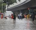
A day after heavy showers battered Mumbai, the rain intensity reduced briefly on Monday morning and picked up momentum again, leading to water-logging at some places and disrupting local train services, officials said.

Weather scientists attribute the early onset of southwest monsoon over Kerala to the influence of the remnants of cyclone Asani that triggered the cross-equatorial flow, a key factor for the seasonal rains.

Skymet said the monsoon this year could be 100 per cent of the long period average (LPA) with a model error of plus and minus 5 per cent.

Though early days, meteorologists point towards a neutral La Nina during the initial phase of the four-month monsoon season this year that starts from June. If this holds true, by the time the rains hit the mainland, it could mean there would be one less reason to worry about the prospects of the monsoon this year. Weathermen said making any accurate prediction of how El Nino will behave and what impact it can have on the progress and distribution of rains is difficult to say at this point. A clear picture will emerge around late May or early June.

Prime Minister Modi last week called for optimal grain storage, fire audits and mock drills in hospitals as preparations for the harsh summer forecast by the meteorological department.

The southwest monsoon might finally start withdrawing from parts of North-West India over the next three days, signaling the end of its four-month journey over the country that started in June, the India Meteorological Department (IMD) said. However, though the retreat might begin from next week, the rains might not descend quickly, as the met department predicted fresh spells of rains in Vidarbha, Chhattisgarh and east MP on September 21-22 and over Odisha, Coastal areas north Andhra Pradesh and Gangetic West Bengal on September 19-21. "Due to anti-cyclonic flows over northwest India at lower tropospheric levels, dry weather is very likely over west Rajasthan, Punjab, Haryana, Chandigarh and Delhi during the next five days. "Hence conditions are becoming favourable for the withdrawal of Southwest Monsoon from parts of northwest India during next three days," the IMD said.
After two days of moderate showers, the met department on Friday forecast "intense heavy rainfall" in Mumbai on late Saturday and Sunday.

The orange alert implies that authorities should be ready to handle situations arising out of severe weather.

Nineteen people have been killed in rain-related incidents in Uttar Pradesh in the past 24 hours, the state relief commissioner's office said Monday evening.

A normal monsoon will augur well for the country's agriculture sector and boost crop yields. However, good rains - and surplus crops - could also depress prices, hurting farm income, unless adequate steps are taken.

The Met office had said Monday that significantly higher-than-normal temperatures may have an adverse impact on wheat and other crops.

Cyclone Biparjoy made landfall near Jakhau Port in Gujarat on Thursday evening with a wind speed of 115-125 kmph gusting to 140 kmph as heavy rains lashed the coastal region, where several areas plunged into darkness due to power cuts and a large number of trees, electric poles and hoardings got uprooted.

Yuvraj, 30, was part of the Indian team that played in the 2014 World Cup at The Hague in the Netherlands.

El Nino is expected to occur in August-September, but it is unlikely to have any major impact on the monsoon, and the weatherman expects a positive Indian Ocean Dipole, which has a strong influence on rainfall in the country.

The Ayanagar weather station recorded 122.8 mm between 8.30 am on Wednesday and 8.30 am on Thursday, which was 11 times the normal rainfall.

IMD director general K J Ramesh said the Met wasn't being conservative and weather patterns indicated that there was a possibility of rainfall being very near to the 50-year LPA of 89 cm.

A depression has formed over the Bay of Bengal and it will cross the coast between Tamil Nadu and Andhra Pradesh by early November 19, the India meteorological department said on Thursday, as rains lashed Chennai and its neighbouring districts, with forecast of more spells.

The Santacruz weather station in the suburbs recorded 129.4 mm rain between 8:30 am and 5:30 pm on Thursday. The Colaba weather bureau in Island City reported 18.8 mm rain during the same period.

This should augur well for the rabi crops as delayed withdrawal will leave enough moisture in the soil for early sowing.

'Very heavy with isolated extremely heavy rainfall (>200mm) forecasted for N Konkan including Mumbai in 24 hrs. Entire west coast very active monsoon'

The Southwest Monsoon usually covers the entire country on July 8. The earlier normal date for the monsoon to cover the entire country was July 15.

The India meteorological department has stated that day temperatures are likely to be above normal by 0.5 degree Celsius, reports Sanjeeb Mukherjee.

Several global models are predicting El Nio to appear around the second half of the year, which are the crucial rain-bearing months.

The city has been witnessing heavy rains since Tuesday night, resulting in water logging in many areas.

Monsoon will be insufficient this year.

Data spanning the years 1951 to 2014 show that temperature and pressure conditions at specific locations in the Arctic region during the pre-monsoon period correlate with the Indian summer monsoon rainfall, points out Charu Bahri.

It was the second straight week of gains for the benchmarks.

The heavy rains led to water level in various dams in the state rising to the red alert mark, prompting the government to open one of the shutters of Cheruthoni dam of Idukki reservoir in the afternoon.

Anything between 96-104 per cent of the LPA is considered as normal rainfall while precipitation in the range of 104-110 per cent is termed 'above normal'

The IMD, in its onset date forecast on May 15, had said the monsoon is likely to hit the southern state on June 5, four days after its normal arrival.

The low-pressure area over the South Andaman Sea and adjoining southeast Bay of Bengal is very likely to move northwestwards and intensify into a depression by Saturday, the weather office said.

The IMD attributed the projection to a weakening of El Nio and the Indian Ocean Dipole turning positive.
Twelve of the 36 meteorological subdivisions recorded deficient rainfall, while the rest witnessed normal to excess rain. In total, 38 per cent of the 662 districts received below-normal rain.

Torrential rains pounded the tiny Himalayan state of Sikkim and the tea growing region of North Bengal, causing landslides that cut off National Highway-10, the main road linking Gangtok with the rest of the country.

Contrary to some predictions, rainfall is adequate so far.

Heavy rains lashed parts of Jammu and Kashmir on Wednesday, triggering flash floods and landslides that blocked the strategic Jammu-Srinagar national highway with hundreds of vehicles stranded, and prompted authorities to shut schools in Doda, Kishtwar and Ramban districts.